
On August 28, 2023, China’s Ministry of National Resources released the ‘2023 Edition’ of the Standard Map of China, during its ‘National Mapping Awareness Week’. The map continues to show the entire State of Arunachal Pradesh and the Aksai Chin region within China’s borders, as well as the entire South China Sea. A ‘10-dash line’, east of Taiwan, shows Taiwan within China’s territorial boundary. China claims that the map is compiled based on the drawing method of national boundaries of China and various countries in the world. According to China’s state media, the Ministry of Natural Resources will also release digital maps and navigation and positioning for use in various fields including “location-based services, precision agriculture, platform economy and intelligent connected vehicles.”
Release of this map just before the G20 Summit in New Delhi on September 9-10 is deliberate to provoke leaders attending the event, particularly India, Japan, South Korea, Indonesia, the US and UK. There is speculation that Chinese President Xi Jinping may not attend the summit in-person but such territorial claims have been made by China earlier also – so what is new?
Despite the US sanctions, US military plans to release thousands of drones to counter China over the next two years and whatever else, American, EU, British and IMF officials have been making a beeline for Beijing, especially after recent expansion of BRICS that has jolted the West.
The Chinese map is a message to India at a time when opinions are being aired that after the “informal” meeting between Prime Minister Narendra Modi and Chinese President Xi Jinping on sidelines of the recent BRICS Summit in South Africa, China is veering towards “disengagement” and “de-escalation” in eastern Ladakh? However MP Subramanian Swamy described the meet from a different perspective as is visible in his tweet below:
China would have noted how the Union Home Minister Amit Shah thundered in Parliament on August 6, 2019 saying POK and Aksai Chin would be taken back and he would give his life for it. This was perhaps one reason why China invaded eastern Ladakh in May-June 2020; to shut the avenues of access to Aksai Chin from India. Now PLA is carving tunnels and shafts into a hill side 60 km east of Depsang for constructing reinforced shelters and bunkers to protect troops and weapons against aerial, artillery and drone attacks.
August 28 as the release date of the Chinese map is significant on two counts. First, the India-China standoff at Doklam Plateau in Bhutan ended on August 28, 2017. But China has continued to build up in the region with PLA occupying part of the Doklam Plateau and building militarized villages in Bhutanese territory.
The second significance of the release date of the Chinese map is that it coincides with the Indian Army occupying the Kailash Range in eastern Ladakh three years back in 2020. This was an excellent strategic move that surprised the PLA although when India vacated it, the paid media termed it of no strategic significance (sic).
Ironically, most events in India are linked to elections. The second anniversary (not first) of the ‘surgical strikes’ was celebrated on a grand scale because of upcoming elections. So, is the case now; government-sponsored program on the third anniversary of occupation of Kailash Range through a video interview, which should have been showcased in 2020 itself.
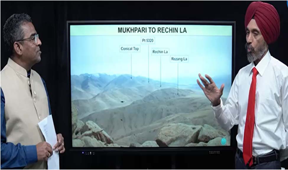
The then GOC 17 Mountain Corps Lt Gen. Savneet Singh explains in the video how Indian troops in August 2020 occupied the Kailash Range from Rezang La to Mukhpari on the heights of Conical Top, Point 5320, Rechin La and Rezang La. The journalist interviewing the General then says that the “operation in Ladakh compelled China to take the negotiations more seriously and disengage at the most crucial face off points on the north and south bank of Pangong Tso. This is a calculated, mischievous and false statement to deceive the public and pull wool over their eyes.
The PLA only fell back along the north bank of Pangong Tso, whereas. Indian troops fell back along both the north and south banks of Pangong Tso. China did take the occupation of Kailash Range seriously because Indian troops directly overlooked the PLA garrison at Moldo but it is important to understand what disengagement actually happened on the north and south bank of Pangng Tso.
Indian troops fell back to the Dhan Singh Thapa post between Finger 3 and Finger 2 on the north bank, which is the lone Indian post on the north bank. The PLA fell back from Finger 4 to Finger 8 on the north bank, with both locations continuing to be connected with a metal road. On the south bank, Indian troops vacated the Kailash Range. Overall, the disengagement in Pangong Tso area was at great strategic disadvantage to India. The erudite external affairs minister has no statement or explanation for vacating Kailash Range. The defence minister keeps repeating “not even an inch of territory has been lost’ because his sole focus to avoid his political party appointing him MD (marg darshak) in 2024.
In addition to vacating the Kailash Range in our territory, thousands of sq km of territory has been lost in Ladakh. This includes traditional grazing grounds of locals, forcing migrations. It is intriguing why the prime minister has also been denying Chinese ingress in eastern Ladakh since 2020. However, Subramanian Swamy of the ruling party feels that China has been blackmailing PM Modi. His recent tweet quoted below:
It was only after the recent Modi-Xi “informal” meeting at Johannesburg that India acknowledging Chinese intrusions in Depsang and Demchok has come into public domain. Hence, the attempt to ‘damage control’ using the video of occupation of Kailash Range; but still using subterfuge to cover up the immense strategic disadvantage of vacating the mountain range.
According to Reuters, Xi is likely to skip the G20 Summit in Delhi. Is this a prelude to further activation of the LAC by China? On the other hand, if he does attend the G20 Summit, would a Modi-Xi in-person meeting become an embarrassment because of the issues discussed above? Xi appears to be deliberately snubbing India with Chinese media hinting he may be represented by Prime Minister Li Qiang at the summit. In the same context MP Subramanian Swamy also tweeted:
At the SCO meeting in Uzbekistan in September 2022, attended by Modi and Xi, China distributed maps showing Arunachal Pradesh and Ladakh as parts of China and J&K as a part of Pakistan. This did not find mention in the Indian media. But in confronting China in Ladakh, we forgot that the PLA was forced to withdraw at Nathu La in 1967, Sumdorong Chu in 1986 and at Doklam in 2017 although in Doklam the PLA returned and we let that happen.
Finally, the bigger question is where do we go from here when China has made it pretty clear that it will be status quo in Ladakh? Former Chief of Army Staff General VP Malik says that with China showing no intention to resolve the boundary dispute, shouldn’t India declare the old status of Tibet and drop the ‘one China’ policy
This should have happened long back but do we have the political will to do so or will we let China keep rubbing it in?
The author is an Indian Army veteran. Views expressed are personal.


