
Myanmar’s Coco Islands in the Bay of Bengal have long been the subject of geopolitical intrigue and controversy among analysts, journalists, and policymakers in India and China and across South Asia even before Indian Independence. However, in the recent past these have gained even more significance with reports and evidence of earlier Chinese surveillance facilities and now Myanmar building military infrastructure in the island much to the chagrin of India. The concerns have been since the early 1990s, when it emerged that Myanmar has allowed a Chinese signals intelligence facility on the archipelago. Though this was not substantially established as little evidence came to light for such a facility, bar a heavily weathered radar station, but recent satellite photographs of increased activity on the islands have raised concerns for India.
Historical Claims
Coco Islands, which lies to the 1255-km south-east of Kolkata, is one of the most important islands of South Asia. This is geologically an extended division of the Arakan Mountains or Rakhine Mountains, submerges as a chain of islands in the Bay of Bengal for a long stretch and emerges again in the form of the Andaman and Nicobar Islands. These strategic islands, lying north to Andamans are part of the same topography as India’s Andaman & Nicobar Island. However, the Coco islands are now part of Myanmar, the reason being reluctance of the Indian leadership to hard press for the claim on these islands.
The leasing of control of the Coco islands resulted in poor governance of the islands, which made the British government in India to transfer its control to the government of Lower Burma in Rangoon. In 1882, the islands officially became part of British Burma and became a self-governing crown colony even after Burma was separated from British India in 1937.
During the Second World War, the Andaman and Nicobar Islands and Coco islands were invaded by Japanese forces. In 1943, political jurisdiction of the Andaman and Nicobar Islands along with Coco islands were handed over to the government in exile of Indian freedom fighter Netaji Subhas Chandra Bose then called the Azad Hind government. While political jurisdiction remained under Netaji Bose, the territorial control remained under the Japanese Navy.
Just like Lakshadweep Islands and Andaman and the Nicobar Islands, the status of Coco Islands was in limbo when the Britishers decided to quit India in 1947. During the last few days of the British rule in India, the imperialists were contemplating every possible action that could sabotage the emergence of a strong India. In such a context, the British were planning to deny the free India certain strategic locations including the islands of the Lakshadweep, the Andaman and Nicobar Islands and also the Coco Islands.
The chiefs of staff of the empire never wanted the Coco Islands to become part of free India, but instead wanted it to be governed by Commissioner under the Governor-General of India till the agreement ended. They wanted the Governor to convince Indian leaders that the Coco Islands belong to two new dominions and not free India.
So, the Viceroy Lord Mountbatten knowing the shrewdness of Sardar Patel, took the matter to Nehru and convinced the proposal in an informal term in which he highlighted that India would lease these Islands to Britain for communication purposes. Following these talks, an official request to make the proposed arrangements was sent to Government of India, who agreed to it “without prejudice”.
Nehru’s lack of strategic comprehension and his inability to bargain hard with the Britishers resulted in India losing one of South Asia’s most strategic islands after the Andaman and Nicobar Islands – the Coco Islands. Thus Coco Islands remained/became part of Burma now known as Myanmar in 1948 when it regained independence from the British.
Strategic Importance of Coco Islands
The Coco Islands are of an immense strategic importance in the region, considering its proximity to the strait of Malacca which is a crucial point for the global supply routes of oil from the Gulf. With the reports of increasing military activities of China/Myanmar, the region becomes another hotspot of potential threat and concern and even Chinese notoriety.
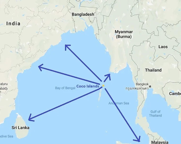
The strategic importance of these islands to India need no further emphasis both by virtue of its location and proximity. China, which has always been eyeing to encircle India in the Indian Ocean Region with its aggressive ‘String of Pearls’ policy has always shown keen interest in this island since last four decades. Since the early 1990s, there had been frequent reports to suggest of China using those islands for military and naval purposes. There were even reports that the islands had been leased out to China in 1994, but Myanmar denied it.
There were also reports that the Chinese have established signal intelligence facilities, maritime bases, and radar facilities that they used to monitor the activities of Indian armed forces, especially the Indian Navy based in nearby Andamans. The Great Coco Island had a short airstrip or around 1000 meter that allowed operation of small aircraft. But the Chinese reportedly had extended it, used solely for military planes as no civilian plane fly from and to there. Coco islands became a matter of great concern for India ever since then.
There were reports of China tracking missile tests and launches by India’s space agency from Great Coco. Indian even cited alleged Chinese radar bases at Manaung Island, Hainggyi Island, Zar Dar Gyi Island, as well as Great Coco. Though in 2005, Admiral Arun Prakash, India’s chief of naval staff, did state that there was no Chinese military installation of any kind on Great Coco. That same year, Myanmar’s junta invited Indian defence officials to visit Great Coco, confirming the presence of an airstrip but no visible Chinese military presence.
Recent Developments
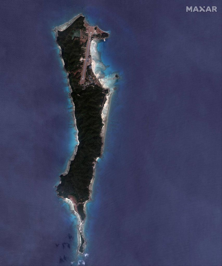
The islands are experiencing a steady makeover, with tell-tale signs of military modernization and facilities to support aircraft. Instead of the phantom Chinese intelligence post still prevalent in the popular imagination, the latest images reveal that Myanmar may soon be intending to conduct maritime surveillance operations from Great Coco Island.
The photos from January 2023 by Maxar Technologies, which specializes in satellite imagery, show renewed levels of construction activity on Great Coco. Visible are two new hangars, a new causeway and what appears to be an accommodation bloc, all of which are visible in proximity to a freshly lengthened 2,300-metre runway and radar station. Visible as of late March on the southern tip of Great Coco, just beyond the causeway connecting the islands, is evidence of land clearing efforts indicating construction work to come.
The past two years of civil war in Myanmar have left it isolated internationally with the military junta, known as the Tatmadaw, increasingly fragile. Beijing has staked a large investment in the country via the China-Myanmar Economic Corridor to access Indian Ocean Sea lanes as a way to bypass the Strait of Malacca – which has acted as a critical sea lane for shipping destined for China’s east coast – and direct energy imports instead over land into China’s Yunnan province.
Myanmar’s military coup has increased Beijing’s influence in the country. With Myanmar’s armed forces struggling to control large swaths of the country and with the economy in freefall, China seems to be shoring up the regime and protecting its investments for now. Chinese companies are believed to be operating on the ground, building major infrastructure projects such as deep-water ports, while the junta is allocating the few troops it has left to protect them.
This has implications for India’s strategic interests in the region, as New Delhi seeks to counter China’s growing influence in South Asia and the Indian Ocean region. With the Coco Island developments, India may soon face a new airbase close by in a country increasingly tied to Beijing.
The militarization of the Coco Islands by the Tatmadaw, combined with the wider Chinese developments occurring inland, could pose a significant security challenge to India and its navy. The Andaman and Nicobar Islands provide India’s Eastern Fleet strategic depth in the Bay of Bengal and command approaches to the Strait of Malacca.
Chinese commercial shipping could soon bypass the strait and offload their cargo in Myanmar, nullifying India’s advantage. Meanwhile an expanded airbase on Great Coco opens the possibility that India may soon have to contend with Tatmadaw eyes watching the movements of its warships.
Fears that China could use Myanmar to monitor the Indian navy are not new, especially in the context of Great Coco. Conspiracy theories dominate the recent history of the Coco Island chain. Despite efforts to debunk them, they underpin almost all the conjecture around Great Coco, with any activity by Myanmar to reinforce its military presence seen as having a Chinese hand behind it.
The salience of Great Coco and its utility as a base for aircraft to survey the Indian Ocean is growing. As stated earlier, the recent photographs released by Maxar add to the body of evidence indicating that the facilities on Great Coco are steadily being upgraded. The runway has been lengthened and new hangars are being built, combined with a limited land reclamation project.
In addition, Signal Intelligence (SIGINT) facilities have come up in the great Coco Island, Ramree Island on the Arakan coast, Hangyii Island in the Irrawaddy Delta, in Rangoon and the Kra peninsula. These new activities indicate a shift in the Indian Ocean strategy of China to a higher gear especially when read in conjunction with Hambantota port in Sri Lanka and Gwadar in Pakistan.
Given the dynamics of the emerging alliances post the declaration of the Third Term by President Xi Jinping and the rule of Military Junta in Myanmar, India would have to stretch the depths of its diplomacy and military capability to ensure its interests are not compromised.


